Wildfire season has started, so we sat down with two wildfire analysts to ask them about how fire impacts watersheds, ecosystems, and water health.
In May 2016, the Fort McMurray fire leapt into the news headlines as it moved up from the Horse River to engulf parts of the city before spreading out into smaller communities and the surrounding Boreal forest landscape. The wildfire was still smoldering months later, when Quinn Barber was hired by the federal government as a Wildfire Analyst. Barber had been working in natural and forest systems biology when he realized his skillset paired well with some work being done by the Canadian Government in fire management and modelling. He says that his coding and analysis
background along with his forest sciences background allowed him to fill a needed role as a wildfire analyst at the Canadian Forest Services, Natural Resources Canada (NRCan) in 2017 as “fire is becoming a bigger and bigger part of our lives”. Since then, he’s partnered on a dozen papers that look at topics such as “where fire is going, what’s going to happen in the future, what’s threatened, and what might have happened if we had not fought fires quite so aggressively in the past.”
DROUGHT AND FIRE
Of the connection between drought and fire, Barber says, “If there’s drought, there is an interaction and a feedback effect with fire.” He explains how moisture is often maintained on the soil’s surface by leaf litter. If that leaf litter and some of the deeper soil layers have dried out during a drought, it can cause a “deep and heavy burning fire”. Barber says, “The soil which is made up of pine needles, peat, and loose organic matter can really burn. This can mean tens of centimeters of soil is consumed.”
These impacts are more severe as the seedbank that usually allows trees and plants to regrow can be wiped out.
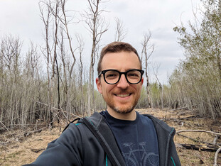
 Quinn Barber stands in front of a former fire site in the Edmonton area. Photo provided.
Barber mentions his colleague, Ellen Whitman, who has studied how high intensity burns at the same spot (known as short interval re-burn) “can result in a forest transition from forest to grassland." This failure to regenerate has been witnessed by some field crews. Parts of northern Alberta where there have been recurring heavy fires are described by Barber as a “moonscape of nothingness”, with some grass or the occasional aspen trying to survive. He adds, “We’re talking about what has been a forest for hundreds or thousands of years is now not a conifer forest. We’re not sure how natural that process is, it may have happened in the past.”
FIRE & WATER SECURITY
François-Nicolas Robinne is a geographer who specializes in disaster risk reduction and has spent the past decade working at “the nexus between forests, wildfire, and water supply”. After some time spent at the Canadian Forest Service working on wildfire risks to water supply, he now works for the Pacific Salmon Foundation as a freshwater habitat analyst. He says that while it is generally known that fires impact water supply and aquatic ecosystems, there has not been a lot of study on the nuances of these ecological issues and their long-term impacts.
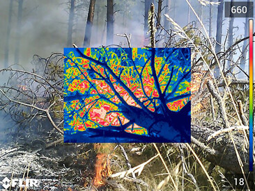
 Thermal imaging allows researchers to visually study the impact of fuels and fire. Photo credit: Rachel Loehman, USGS.
Potential short-term hazardous changes to watershed ecosystems after a wildfire:
- Severe floods, particularly in small or hilly water basins
- Excessive erosion that may lead to various types of landslides and debris flows
- Decreased water quality due to excess sediment, nutrients, and heavy metals (from human pollution)
- Smoke hovering over lakes can deposit excess nitrogen, arsenic, mercury, ash, a number of oily compounds – both in the lake and the shoreline
- Remobilized historic deposits of pollutants (e.g. mercury, arsenic, aerosols) from old mining or industrial sites
- The downstream accumulation of the above changes can lead to sudden fish die-off and severe degradation of aquatic organisms’ habitat

Forests generally act as a filter and sponge for water as their leaves, roots, and soil absorb and store water which means relatively clean and abundant groundwater and surface water from these areas. When fire moves through a forest, it burns the vegetation and leaf litter on the ground and exposes the soil. Heat and ash from the fire also makes soil less receptive to water (hydrophobic), so rainfall will not go into the ground, but run off as overland flow. As overland flow moves, it picks up sediment, debris, and ash that is carried into rivers and streams. Diagram: USGS.
Potential longer-term hazardous impacts to watershed ecosystems after a wildfire:
- Burnt tree roots decay and can cause landslides (observed up to 25 years after wildfire), causing sediment and debris overload in water channels
- Changes to river morphology [shape and direction] through large sediment deposits or fast-moving floods that can impact habitat availability for some aquatic species
- During floods, remobilization of debris (rocks, logs, sediments) stored in the river post-fire
- Accumulation of toxicants in food chains. E.g. bioavailable mercury (methyl-mercury) released after a fire is ingested by micro-organisms and can move up the food chain to unsafe levels for fish and their predators—including humans.
- Changes to the water balance of the watershed can create water supply issues
PYRODIVERSITY: FIRE AND ECOLOGY
One factor that varies greatly from year-to-year in Alberta is when the wildfire season will start. This can depend on when the snow melts and enough rain and heat cause trees to leaf-out. Barber explains that a long gap between these two events can make fire more likely to happen. On the flipside, fire spreads less easily once the leaves and grass come out because “leaves and grass don’t carry fire as well.” However, as things get drier throughout the summer, “it slowly ramps back up”. Barber notes, “That’s what happened in Ft. McMurray. It was in May, in that time before the leaves came out and after the snow came off. All it takes is a windy day and that dry grass from last year will carry fire anywhere.”
The intersection between ecology and fire and part of Barber’s research and he mentions how some trees thrive post-fire: aspen, white birch, jack and lodgepole pines among them. Barber also points to the black-backed woodpecker who has an uncanny ability to find burnt forests to feed on wood-boring insects. Who hasn’t noticed the ubiquitous purple blooms of fireweed against a charred landscape? These plants are a valuable food source to deer, rabbits, and pollinators and were used medicinally by Indigenous people to heal burn wounds.
Robinne says that indigenous people understood that burning the landscape was a form of helping nature with what he calls “pyrodiversity” – where impacts from wildfire are positive and promote biodiversity. He mentions how species like owls looking for small prey and snags (dead trees) or bears in search of berries will be drawn to a burned site.
 Freshwater habitat analyst, François-Nicolas Robinne. Photo provided.
HYDROPHOBICITY: PLANTS & SOIL
When rain follows a wildfire, lack of plant cover may lead to a higher water yield, but the water is harder to store. Plants retain and disperse water across the soil surface and tree roots help replenish groundwater. In essence, Robinne adds, “The watershed remains in a heightened danger state until the vegetation comes back – which usually requires rain.”
Robinne adds that forest litter and soils contain oily compounds at the surface that will move further down into the soil during a fire and create a water-repellent—or hydrophobic—layer. When rain comes, the hydrophobic layer can stop water from being absorbed deeper into the soil and turn it into excess runoff and lateral flow, unstopped by a lack of vegetation. The hydrophobic layer can also act like a “slide”, making it easier for soils to be washed away.
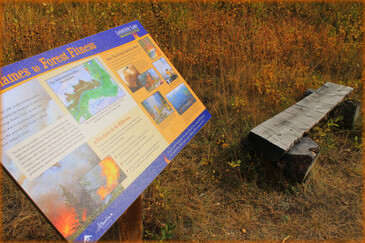
 The Landslide Lake interpretive Fire Trail near Kootenay Plains educates hikers about the importance of fire within ecology. The trail is within the Upper North Saskatchewan Prescribed Fire of 2009. Photo credit: Kirsten Kachuk.
WHAT WE’VE LEARNED ABOUT WILDFIRE IN THE PAST DECADE
When asked what Canadian forest scientists have learned in the past eight years since he started analyzing wildfires, Barber points to the breadth of the 2023 fires. “Many fire scientists would have laughed if you’d said that we’d burn 15 million hectares in a year.” The previous record for Alberta – set in 1989 – was 6.7 million hectares burned.
It’s a difficult task to untangle how much of these fires can be attributed to “the forest legacy” in which forest fires have been suppressed, to climate change, or just simply to hot and windy conditions, like those witnessed last summer.
Barber notes, “A lot of the research goes into how to protect communities, how to protect assets,” while his research focuses more specifically on “how fire will change with a warming and drying climate and how that’s going to continue to impact the composition of the forest.”
Forest health is now viewed in terms of an “age mosaic”, with both young and old growth forests. Barber calls the forests immediately around communities “unnaturally old, because we’ve protected them from fire.” He adds, “If we want a natural environment that is healthy, and that’s resistant – has a lot of strength and depth – we need that age mosaic. That could mean harvesting some of that dense forest that is right next to communities, or investing in firebreaks, for example.” Besides the biodiversity benefits, Barber adds, “A very young forest doesn’t usually carry fire as well as an older forest.” He cites an example from 2023 where a fire encountered a forest under 30 years old and the fire stopped.
“It can protect communities; it can protect wildlife.” Echoing this, Robinne says that a common phrase from the past decade in the fire community is “Learning to live with fire.” When asked what we’ve learned in the past decade, Robinne says he believes we are “re-accepting the role of fire in ecosystems."
"It may seem paradoxical, but for a watershed to stay healthy, it needs to burn... There is finding the balance between wildfire as a watershed and ecological process, and wildfire as a source of risk for people or water security or aquatic ecosystems."
- François-Nicolas Robinne
Canada could learn from other countries such as Mexico, Australia, and parts of the US where local action is encouraged, according to Robinne. “In Canada, we’re still approaching fire management from this top-down approach. He says there are places where “forest management as a whole” now use a “community-driven management” approach. He says that while it may not look as efficient externally, it allows the locals who know the landscape best and what they want from it to drive action and change – and create jobs for locals. Robinne adds, “These are very complex issues and trying to have a one-size-fits-all doesn’t work. That’s essentially what we can learn from other places: to let communities give more input.” To read about local stewardship strategies that combine Indigenous Knowledge and Western science, see the Forest Climate Adaptation Toolkit map links below.
WATER SECURITY AND FIRE: A BALANCING ACT
Both Barber and Robinne emphasize the need to accept fire as part of our
forest and watershed ecosystems. Robinne says, “It may seem paradoxical,
but for a watershed to stay healthy, it needs to burn.” At the same time, there are obvious impacts to the water supply and human health. “There is finding the balance between wildfire as a watershed and ecological process, and wildfire as a source of risk for people or water security or aquatic ecosystems. What we’re trying to learn is how to find this balance.”
LINKS
- To read articles authored by Quinn Barber, go to:
https://scholar.google.com/citations?user=Pafs4BwAAAAJ&hl=en - To read articles authored by Francois-Nicolar Robinne, go to:
https://scholar.google.ca/citations?user=XtWjDUIAAAAJ&hl=en - For wildfire facts, go to:
https://www.canadawildfire.org/wildfirefacts - To view the Alberta Wildfire Status Dashboard, go to:
https://www.arcgis.com/apps/dashboards/3ffcc2d0ef3e4e0999b0cf8b636defa3 - To view the Air Quality Health Index in your area, to to:
https://airquality.alberta.ca/map/ - Forest Climate Adaptation Toolkit
“This interactive map presents real-world examples of place-based stewardship,
strategies, and tools for forest climate adaptation that are rooted in Indigenous
Knowledge (IK) and Western Science (WS).”
https://experience.arcgis.com/experience/f069301a3a6f4f0cb509636c0a93b225/