
As Alberta continues to be Canada’s fastest growing province, there’s a growing need for housing – and a push for more residential development. Housing and quality of life have also been impacted by significant weather and climate events, as the province rebuilds areas touched by recent wildfires and rebounds from floods not so far in the rearview mirror.
The Canadian Climate Institute has just released a new report about how housing and residential development in Canada will be impacted by a changing climate. To find out more, we sat down with one of the authors of the report.

HITTING CLOSE TO HOME
Miller is one of the co-authors on the recently released report, Close to Home: How to build more housing in a changing climate. The report is timely because of the present need and push for more housing that is affordable within Alberta – and the country as a whole.
Miller acknowledges the incredible affordability pressures facing Canadians. She adds, “We know that climate-related disasters like flooding and wildfires are getting worse and affecting more households and communities.” The report combines these two issues and models outcomes from flood and wildfire-related losses for new housing, looks at current policies around new housing developments, and makes recommendations for building housing “that is so desperately needed, without putting many of these new homes in harm’s way.”
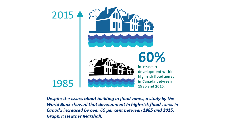
Urban areas are more likely to be impacted by floods because of an increased number of impervious surfaces which could lead to a higher frequency and magnitude of floods. These floods are more likely to overwhelm current infrastructure such as storm drains and ponds, as population density increases.
HOMEOWNERS: LACK OF AWARENESS ABOUT RISK
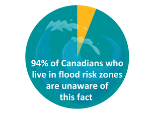
A national survey done by the University of Waterloo in 2020 also showed that 94% of people living in a flood risk areas are unaware of this fact. A couple of issues factor into this lack of awareness. Miller says that information is not always readily available and “the disconnect between people’s understanding of their risk and the reality is concerning, as it can leave people unprepared when disaster strikes.” Hazard mapping can be outdated, absent, or hard to access and Miller adds, “Canada lags behind other peer jurisdictions in that provincial regulators generally don’t require that risk be disclosed in real estate transactions in any kind of comprehensive way.” The CCI hopes this report will help increase knowledge for the public, developers, and legislators to bring about some needed change.
MAPPING PROGRESS
Progress is being made through the Flood Hazard Identification and Mapping Program, a joint effort between provinces/territories and the federal government. Miller points out, however, that coverage for mapping areas can be spotty and need to better inform future development and housing purchases. Some Maritime provinces have factored in climate projections and BC, Quebec, and Saskatchewan are also making some progress on this front. But unfortunately, a lot of current mapping may still “be decades old, and without climate projections.” Because Alberta is at reasonable risk of flood and wildfire, these climate projections would be an asset as the province continues to grow.
PROACTIVE VS REACTIVE MEASURES
The report says disaster assistance programs encourage municipalities to “rely on post-disaster recovery rather than proactive risk avoidance.” Miller calls disaster assistance programs in Canada a moral hazard, “as investors, homebuyers, and local governments may be more willing to approve development or purchase property in high-risk areas because they know they can rely on government support when disaster strikes.” In simple terms, it enables risky future development. The report advocates for new developments in high-risk areas not being eligible for assistance “to send a strong signal that certain areas are unsafe for development and to avoid socializing these costs to all Canadians.”
LAND USE POLICIES FOR HIGH HAZARD AREAS
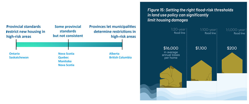
The report says that only five of Canada’s 13 provinces/territories have land use policies that limit housing development in high hazard flood areas. Municipalities, developers, renters are often in the dark because of outdated or inaccessible information. The two standout provinces are Saskatchewan and Ontario, where the province sets provincial-level standards that restrict new development in high-risk areas. On the other end of the spectrum, BC and Alberta take a more hands off approach. Alberta discourages development in a floodway, but leaves it to municipalities to restrict development, with cautions about the implications of ignoring restrictions.
“Affordability is key, and as governments aim to improve affordability by building more housing supply, it’s critical they don’t undermine their own efforts by allowing a lot more housing in risky areas.” – Sarah Miller
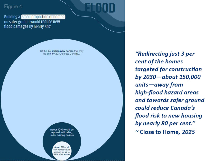
The report stresses that “land use policy is the most effective and cost-effective way to keep new housing safe from the most serious climate hazards. Studies consistently show that land use policies that direct development into safer areas provide significant benefits, including reduced damage and disaster recovery costs, and fewer long-term disruptions to communities.”
Wielding land policy tools could deliver big savings, according to the report, as projections shows that “the very riskiest areas are responsible for a vast majority of losses.” Alternate locations often exist and moving new builds away from these highest risk areas would still allow for housing demand to be supplied.
FACTORING IN SOCIAL VULNERABILITY
A 2022 report by Public Safety Canada on flood risk and relocation took into account the Social Vulnerability Index (SOVI). The socially vulnerable are particularly impacted by flood risk areas within the prairie provinces. Miller says that studies done within and outside Canada, but especially those in the US, “show that equity-seeking groups and low-income households are overrepresented in flood-prone areas.” The report points out that one of the benefits of land use policies and bylaws is that they help promote equity.
ADJACENT REPORT ON INDIGENOUS HOUSING RESILIENCE
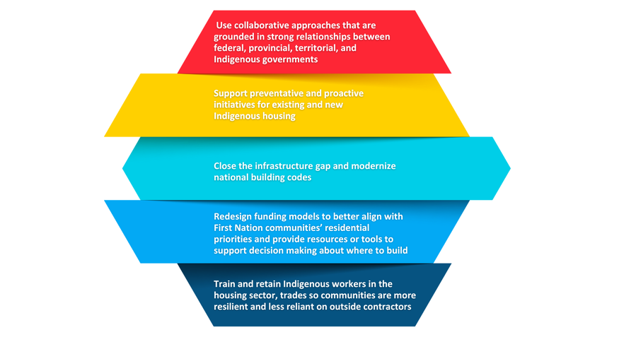
The CCI also commissioned a standalone report by Shared Value Solutions to explore the challenges facing Indigenous communities, particularly on reserve. Miller says, “We know that Indigenous communities are subject to disproportionately high flood risk and face more severe and prolonged impacts from flooding.” The CCI wanted to ensure there was a unique document (Indigenous Housing and Climate Resilience Report) to address the challenges in building resilient homes in safe locations in Indigenous communities because of the historical and geographical contexts.
“Land use policy is also important for
promoting equity.” ~ Close to Home, 2025
The report highlights how “reserve lands are disproportionately exposed to environmental hazards, such as flooding, compared to non-Indigenous communities.” Among the reasons for this disproportionate vulnerability are:
- Historical and current marginalization (including forced relocations to substandard lands)
- Lack of infrastructure
- Socioeconomic factors
The consequences of these compounding impacts for Indigenous peoples are manifold. Two reports that look at these impacts for Indigenous communities, challenge the term natural disaster and instead calling it an “unnatural disaster” because of its human-based origins and impacts that go beyond weather systems.
Some of the summarized recommendations from this report are shown in the graphic below:
HOPE ON THE HORIZON: CANMORE AS CASE STUDY
There are communities that are being more proactive, like the Town of Canmore. Following the 2013 flood, the town worked to create what is now the Steep Creek Hazard Overlay District. This proactive land use bylaw keeps development away from flood hazard areas, “prohibits development in high-hazard areas and requires a risk assessment in moderate hazard zones,” according to the CCI report. There are also construction guidelines to mitigate issues and hazard ratings can be viewed by the public, to increase transparency for home buyers. View the overlay map of Canmore here.
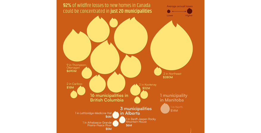
THE HAZARDS OF WILDFIRE
Although not the focus on this article, Alberta also has a number of communities that are at risk of wildfire. The greatest current residential wildfire risk is highest in Alberta ($170M average annual losses per year) and BC ($400M average annual losses per year).The Report showed that projections show that most wildfire losses in Canada will likely be concentrated in 20 regions. Of these 20 regions, 3 of them are in Alberta. (For the sake of anonymity, the exact municipality has not been named. (To learn more about impacts of wildfire, see pages 46-57 of the report.)
BECOMING INFORMED: ADVICE FOR CURRENT OR FUTURE HOMEOWNERS
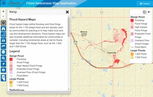
- In Alberta, potential buyers in some areas can look at the province’s public flood maps online to try to get a better understanding of their risk: https://floods.alberta.ca/
- The federal government is working on a public flood portal to give Canadians better ability to understand their risk, but this work is not yet complete
- Stay informed: Partners for Action (P4A) is a research initiative through the University of Waterloo that “seeks to empower Canadians to become flood resilient by promoting awareness and preparedness actions” and provides strategies to prevent or adapt to flooding
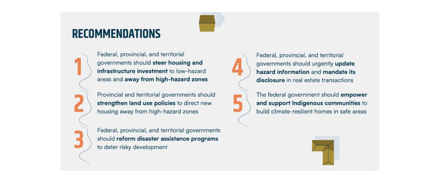
BUILDING A MORE RESILIENT FUTURE: RECOMMENDATIONS FROM THE REPORT
LINKS TO LEARN MORE
- Read the report, related podcasts or news releases: Close to Home: How to build more housing in a changing climate.
- Read the Indigenous Housing and Climate Resilience Report.
- Adapting to Rising Flood Risk: An Analysis of Insurance Solutions for Canada is a report by Canada’s Task Force on Flood Insurance and Relocation (2021-2022).
- Read the 2020 survey Canadian Voices on Flood Risk (2020), by Partners for Action.