RHAP Phases

PHASE 1: Pilot Project (2016-2018)

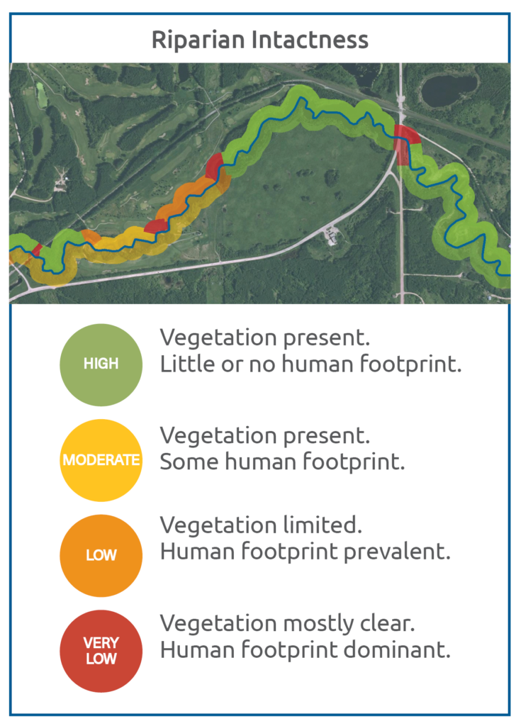
NSWA developed a pilot project to assess the condition of riparian areas in the Modeste sub-watershed

A new method using satellite imagery to classify riparian "intactness" at a broader scale was developed by Fiera Biological Consulting Ltd. 

Riparian intactness: the extent to which natural riparian habitat or shorelines have been altered by human activity

3 datasets came from the pilot project:

3 riparian datasets

1. Riparian intactness
2. Watershed Pressure from land next to the riparian area
3. Prioritization for restoration and conservation activity

By 2021, over 17,300 km of shoreline were assessed across the NSR watershed

The results show that approximately 46% of riparian areas are rated as High Intactness in the North Saskatchewan River watershed.

  • Riparian intactness projects have been done in the Battle River, Athabasca River, Beaver River, Red Deer River, Lesser Slave Lake and South Saskatchewan River watersheds
  • Over 40,000 kilometres of shoreline have now been assessed using this new method

To view the Intactness reports by County, Watershed or Municipality, click here

RESOURCES FOR PHASE 1

  1. Assessment Methods Validation Report by the GoA (2019)
  2. Land Cover Dataset (2021) GoA Open Data Source
  3. Riparian Intactness Dataset (2021):  GoA Open Data Source
  4. Riparian health presentation by Dr. Shari Clare and Mary Ellen Shain (2021)

FUNDERS

CAP & AB logos


PHASE 2: Create a Riparian Strategy with management tools

2021:  The Riparian Conservation and Restoration Strategy was approved 

An interim Riparian Health Target of a minimum of 65% High Intactness and no more than 25% low intactness was set

2021-2022: Riparian Condition Municipal Summaries, were created with other WPACs to deliver municipal-specific report cards to be presented to municipal councils

FUNDERS

CAP logo


PHASE 3: Creating & launching the Riparian Web Portal

In 2017, the NSWA commissioned BlueGeo to develop the Riparian Web Portal to provide the public with access to riparian data and resources

Other WPACS, including the Battle River Watershed Alliance, helped us officially launch the Riparian Web Portal in February 2021

THE RIPARIAN WEB PORTAL

  1. Provides access to riparian data and summary tools.
  2. Shares examples of on-the-ground restoration and conservation projects.
  3. Provides links to riparian programs and grants, and offers recommendations for better management practices

The NSWA and Battle River Watershed Alliance developed a workshop series to train anyone wanting to become a Web Portal user

This project received an Alberta Emerald Award in 2022.

FUNDING ACKNOWLEDGEMENTS

Funding for the Riparian Web Portal was provided through the Government of Canada’s Environmental Damages Fund, Watershed Resiliency & Restoration Program and the Canadian Agricultural Partnership. Additionally, we have received cash and/or in-kind contributions from Battle River Watershed Alliance, Red Deer River Watershed Alliance, Athabasca Watershed Alliance, Lakeland Industry & Community Association, Lesser Slave Watershed Council, and Alternative Land Use Services (ALUS).

RESOURCES FOR PHASE 3

Riparian Web Portal

"Water Canada" article about the Riparian Web Portal 

Legal Foundations for Municipal Riparian Management - full document

Legal Foundations for Municipal Riparian Management - 4-page summary